// OPEN INTELLIGENCE — PUBLIC ARCHIVECASE FILE · THE RECORD
FRFRFR
← THE ARCHIVE
◆ CASE FILEThe facts, corroborated

The Neah Bay Radar Intercept (1954)

On the evening of 22 June 1954 Air Force radar in Washington State tracked an unknown target off the coast, and two F-86D interceptors sent after it watched one blip split into two on their own scopes before it slid away. The Air Force's evaluation called them "true airborne targets" with an estimated pull-out speed of Mach One or better. This is the record of what was tracked, not a verdict on what was over the Pacific.

◆ THE SHORT VERSION

  • The Neah Bay Radar Intercept (1954) is a reported UAP case in Pacific off the Washington coast, about 38-40 miles south-west of Neah Bay, USA, 22 June 1954.
  • An F-86D pilot closing on the radar target reported that its blip "separated into two 'clear distinct' blips" on his own scope before both slid away.
  • The Air Force's evaluation called them "true airborne targets", the size of B-36 or B-52 returns, "with an estimated pullout speed of Mach One or better."
  • Neither interceptor pilot saw anything with his eyes, and the site technician ruled out radar malfunction, according to the summary.
  • The FBI memo written that night and the Air Force summary disagree on the altitude, from 1,500 to 2,000 feet in one to 15,000 and 25,000 feet in the other.
  • For this case Fractured Realities holds 1 distinct source, 1 corroborating primary document and 3 distinct claimants on its resolved list.
  • The archive grades it L4 · OFFICIAL RECORD — a released government record names who saw it, the top of our scale, though no independent testimony sits beside that record.

Counts are resolved totals of what sources say, computed 2026-10-03; the reported details above are claims in the record, not findings. A record of reports, not a verdict on what happened.
The Neah Bay Radar Intercept (1954)
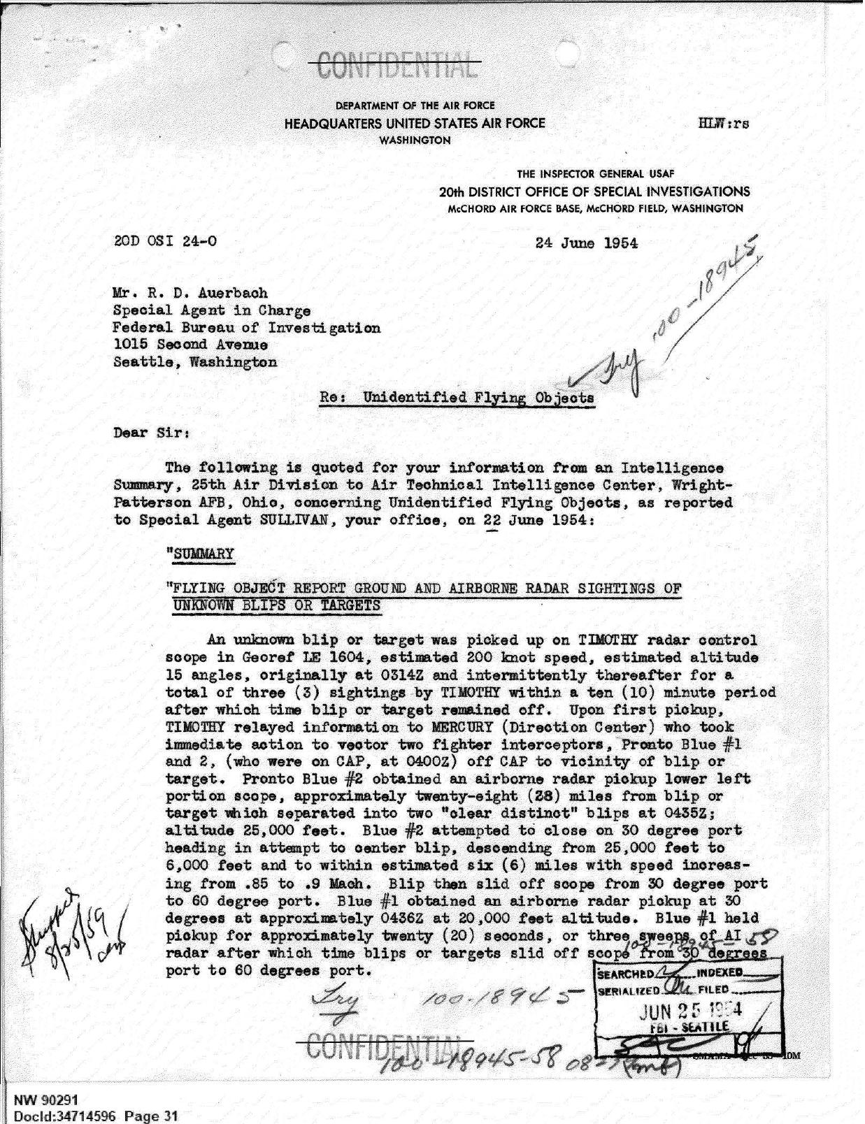
From the case file · released government record · FBI-UAP-D013, p. 31 · the Air Force intelligence summary of the TIMOTHY radar intercept, 24 Jun 1954 · released by the Department of War, 12 Jun 2026 ↗
EVENT DATE
22 June 1954
LOCATION
Pacific off the Washington coast, about 38-40 miles south-west of Neah Bay · USA
COORDS
47.97°N 125.22°W
INDEPENDENCE
L4 · OFFICIAL RECORD
SOURCES
1 distinct
CLAIMANTS
3
STATUS
Known from released government records
NUMBERS COMPUTED 2026-10-03 · RESOLVED COUNTS, NOT A VERDICT

VIEW ON ATLAS →

The blip split while the fighters were closing on it. Radar site TIMOTHY had picked up an unknown target at an estimated 200 knots and relayed it to the direction centre MERCURY. Two F-86D interceptors on combat air patrol (Pronto Blue 1 and 2) were vectored off station toward it. Blue 2 caught it on his own radar about 28 miles out and the return then "separated into two 'clear distinct' blips". Diving from 25,000 to 6,000 feet at up to .9 Mach, he closed to about six miles before the blips slid off his scope. Blue 1 held a contact for some twenty seconds before it too slid away. Neither pilot saw anything with his eyes.

What is on the record

Two papers in the FBI's Washington State file, FBI-UAP-D013, carry the case. The first is a Seattle office memo written that night by Special Agent J. Francis Sullivan, headed "Neah Bay 6/22/54". It records an OSI agent's call at 11:10 PM: a target 38 to 40 miles south-west of Neah Bay, two planes scrambled from McChord Field and a blip that split in two and faded "presumably because of fast air speed". The second, an Air Force OSI letter of 24 June from McChord, quotes the 25th Air Division's intelligence summary of the same report.

That summary names the pilots as 2nd Lt Edward E. McBride and 2nd Lt Hilson L. Sewell of the 317th Fighter Interceptor Squadron. They were questioned separately within four hours. A technician at the site ruled out radar malfunction. Balloons, ships and known aircraft were ruled out. The summary notes a slight temperature inversion at 5,000 feet that evening and judges that it would affect only a limited area. The evaluation reads "true airborne targets" the size of B-36 or B-52 returns, "with an estimated pullout speed of Mach One or better."

The two papers disagree in places. The memo gives 1,500 to 2,000 feet and credits the Neah Bay station. The summary gives 15,000 feet for TIMOTHY's return and 25,000 feet at the split. Project 1947, which transcribes these papers, found no trace of the case in Project Blue Book.

Why it sits where it does

L4 · OFFICIAL RECORD — a released government record names who saw it. The observers are two named interceptor pilots and the controllers at site TIMOTHY. No independent testimony sits beside the record in the archive, and the tier measures sourcing rather than truth. What the radars painted off the coast is not resolved here.

◆ CORROBORATION
✓FBI-UAP-D013_WA-UFO-Investigation_1952-1960 (government primary)
✓3 resolved claimants
◆ SOURCES

Everything this file draws on, in the open — reports, not reality. Check us.

Documents & published sources

Government records, papers and journalism the archive links to this case.

government record · 1
DoW UAP Release · 1
FBI-UAP-D013_WA-UFO-Investigation_1952-1960corroboration
RADARMILITARY WITNESS1954USA

CASE FILES STATE THE RECORD AS OUR ARCHIVE HOLDS IT — FACTS, NOT OPINION. REPORTS, NOT REALITY.

◆ CONTINUE READING
The Neah Bay Radar Intercept (1954) — Case File · Fractured Realities